Explore Philippines (Batangas)
Batangas - From The Lowest Volcano To Deeper Dives
BRIEF DESCRIPTION
A province that is famous for excellent dive sites and the world’s lowest volcano, Batangas is going nowhere but up. It is a thriving tourist destination replete with open beaches and sheltered coves, subterranean caves and deep harbors, a preserved heritage and brave men in history.
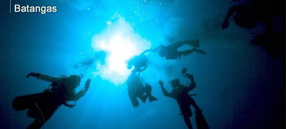
Found in the province is world-known Anilao and its many dive sites that are ideal for poking around and observing marine life, and outstanding for macro photography. Multi-hued crinoids are prolific. The variety of nudibranchs is unmatched. Night dives are especially nice and often reveal unusual creatures like sea hares, sea goblins, catfish eels, ghost pipe fishes, blue-ringed octopuses, mandarin fishes, and snake eels. The area’s best known dive site, coral-covered Cathedral is spectacular at night. One of the prettiest dives in the area, Sepok has nice coral gardens and a vertical wall.
Taal Lake and Volcano in Batangas is Southern Luzon’s centerpiece attraction. Known to be the smallest in the world, it is a volcano within an islet within a lake within a crater within a volcano. The town of Taal reigns as one of the two most culturally preserved sites of the Spanish colonial era; the other is Vigan in Ilocos Sur. The village in Taal conforms to the old town layout combining the municipal hall, school, church, and houses.
Among the multitude of popular tourism activities to be had in the province are heritage tours, pilgrimage tours, scuba diving, shopping, mountain climbing and trekking, swimming, and snorkeling. Batangas is located only 110 kilometers south of Metropolitan Manila, and is very accessible from the national capital by land.
GEOGRAPHY
The province of Batangas is bounded on the north by the provinces of Cavite and Laguna, on the south by the Verde Island passage, on the east by the provinces of Quezon and Laguna, and on the west by the South China Sea. It has a total land area of 316,580 hectares, 50% of which has a grade of less than 15 degrees. The terrain is generally rolling while the rest are mountainous and hilly.
CLIMATE
Batangas has a naturally cool climate. It experiences two types of seasons: dry from November to April and wet for the rest of the year. Mean annual rainfall is at its maximum in July, at 1.5 to 2.5 meters. March is the driest month. Mean monthly temperature is 82 degrees Fahrenheit. February is the coldest month, averaging 69 degrees Fahrenheit, while May is the hottest, at 96.1 degrees Fahrenheit.
POPULATION
The population of the province totals 1,905,348 as of May 2000.
LANGUAGE / DIALECTS
Batangueños are bilingual, with Tagalog and English as the basic languages used in business, government, schools, and everyday communication.
POLITICAL SUBDIVISION
The province is composed of 32 municipalities. Capital is Batangas City.
posted by Nestor P. Mose @ 4:18 PM
![]()


0 Comments:
Post a Comment
<< Home